
Visitor Attractions
Castles, distilleries, visitor centres, bridges, so much to explore.
More visitor attractions
Walking
Put on your trusted walking boots and head out to explore our extensive network of woodland, moorland and riverside walks.
More about walking
BikeGlenlivet
Enjoy fun-packed, flowing single track and stunning scenery at our purpose built mountain bike trails.
More about bikingUpcoming Events
-
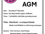
Friends of Ben Rinnes Talk & AGM Thuesday 9th May 2024 @ 19.30 (AGM) 20.00 (Talk)
-
Moray Walking Festival - Carn na Glascoill – from the Braes of Glenlivet Friday, 21 June 2024 @ 10:00 - 16:00
-
Moray Walking Festival Drumin – Twinflower, a Tower House, and a Riverside Stroll Tuesday 18th June 2024 @ 18.00 - 20.30